
 To display the tab
To set up map height, use the Height side panel tab.
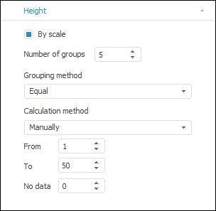
The side panel tab is used to set up the height of map elements. The height is calculated by a scale, which determines the set of number intervals and the height of the map for each interval.
NOTE. On setting up the scale take into account the following feature: boarding values are always included into scale smaller interval. For example, there is a scale with three intervals: less than 25, from 25 to 50, more than 50. The 25 value will be included in the less than 25 interval, and the 50 value will be included in the from 25 to 50 interval.
The By Scale checkbox determines the calculation method for the height scale. If the checkbox is deselected, the scale is set up automatically and if it is selected, the calculation parameters should be set by the user.
Height scale calculation parameters:
Number of Groups. Specify the number of scale intervals: from two to ten.
Grouping Method. Select a method for calculating scale intervals:
Equal. The entire range of source data is divided into the specified number of equal intervals. The number of values in the source data included in the interval is not taken in account.
Quantiles. The entire range of source data is divided into the specified number of intervals to make each interval contain equal number of values from source data included in the interval. The interval length is not taken into account.
Calculation Method. Specify the calculation method for minimum and maximum heights:
Auto. Values of minimum and maximum heights are determined automatically.
Manually. Parameters of height calculation are set by the user. The range of available values: [1, 100]. Use the boxes:
Min. Minimum height value.
Max. Maximum height value.
No Data. Specify the height to be used for the regions with no data.
Scale intervals will be calculated based on these values.
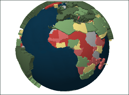
As the Globe. If the checkbox is selected, the displaying of 3D map as a globe is available. To rotate the globe, use mouse pointer.
NOTE. For correct displaying the map must be converted.
The example of the map displayed as the globe:
See also: