Executing this example requires an XML file named MapXmlExample_RU.xml, topobase Russia.svg, and an HTML page, that contains a map. Map settings must be converted to JSON.
NOTE. When XML is automatically converted to JSON, the "@" character, which does not need to be removed, appears before attributes.
The XML file must contain the following items:
A scale with the ID AreaVisualScale (in theitems dictionary);
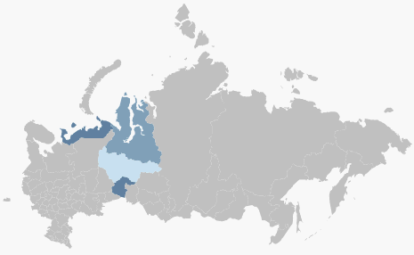
A data source with the ID source (in the data source list ), that stores data for the following four regions: the Yamalo-Nenets Autonomous District, Khanty-Mansijsk Autonomous District, Tyumen region, Nenets Autonomous District.
To set up map fill factor, add the MapAreaVisual item to the Visuals item.
NOTE. In case object properties are described as items and not as attributes, the following syntax is used: ObjectName.PropertyName (such as, MapLayer.Visuals).
"MapLayer.Visuals":
{
"MapAreaVisual" :
{
"Name" : "Harvesting",
"Visibility" : "Visible",
"Index" : "0",
"Id" : "AreaVisual",
"MapAreaVisual.Background" :
{
"DataDependency" :
{
"IsDependent" : "True",
"MapScale" : "{AreaVisualScale}",
"TypeArguments" : "Brush",
"DataSource" : "{source}"
}
}
}
}
After executing the example, fill factor is set for the four regions:
See also: