Operating system requirements: iOS 5.0 or later.
Mobile device: iPad.
This example implements executing the following operations:
A tooltip for area parent layer is set.
A constant value of color scale is set for map area visual elements.
The development environment console displays map area name, center point coordinates obtained from platform attributes, and also area center geographic coordinates.
A new map area center is set.
Executing the example requires to place the following code in the body of the mapChart:touchDownInShape: method of the ViewController class (see the Creating a Map with a Timeline section):
// Compare selected area identifier with the specified one
if([shape.ID isEqual:@"RU"] == YES)
{
    // Create an object for working with a tooltip
    MapTooltip *tooltip = [MapTooltip new];
    // Set tooltip text
    tooltip.text =@"Novaya Zemlya";
    // Set tooltip text color
    tooltip.borderColor = [UIColor blackColor];
    // Set tooltip for parent layer
    [[shape parentLayer] setTooltip:tooltip];
    // Pass tooltip of area parent layer
    [shape setTooltip:[[shape parentLayer] tooltip]];
    // Get array of area visual elements
    NSArray *visuals = [shape visuals];
    // Parse visual elements in cycle
    for(MapAreaVisual *visual in visuals)
    {
        /* Determine whether map area background fill parameters
        do not depend on data source */
        [[visual background] setIsDependent:NO];
        /* Set visual element fill parameters,
        used if  there is not scale binding */
        [[visual background] setValue:[SolidColorBrush solidColorBrushWithColor:[UIColor colorWithHex:@"86b7fb"]]];
        // Redraw map
        [m_view invalidate];
    }
    // Get area name
    NSString *title = [shape title];
    // Get area center point retrieved from platform attributes
    CGPoint centerPoint = [shape centerPoint];
    // Get geographic coordinates of area center
    CLLocationCoordinate2D centerPointCoordinate = [shape centerPointCoordinate];
    // Display obtained values in the development environment console
    NSLog(@"Area name: %@",title);
    NSLog(@"Area center coordinates obtained from platform attributes: (%f,%f)",centerPoint.x,centerPoint.y);
    NSLog(@"Area geographic center:");
    NSLog(@"Latitude: %f", centerPointCoordinate.latitude);
    NSLog(@"Longitude: %f", centerPointCoordinate.longitude);
    // Determine the point that determines area center
    CGPoint center = {0.25, 0.35};
    // Set new area center point
    [shape setCenter:center];
    // Get the rectangle that limits the area
    CGRect rect = [shape bounds];
    // Zoom and scroll the screen to the obtained rectangle
    [mapChart zoomToRect: rect];
}
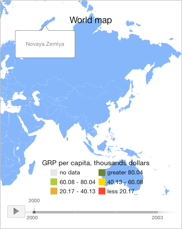
Then manually press the map layer area with the RU identifier. As a result, the map is zoomed and scrolled to this area. Fill color for all areas is changed for blue. A tooltip is also displayed in the new center point of the specified area:

The development environment console displays map area name, center point coordinates obtained from platform attributes, and also area center geographic coordinates:
Area name: Russian Federation
Area center coordinates obtained from platform attributes: (744.861206,180.082138)
Area geographic center:
Latitude: 69.423810
Longitude: 103.997054
See also: